The Sestieri of Venice
A Guide to Venice's Sestieri
Since its origins, Venice has been divided into six Sestieri, the city's historic districts. While most cities are divided into "quarters" or neighbourhoods, Venice is unique in using the term Sestiere, reflecting its distinctive urban layout and centuries-old administrative tradition. The word "quarter" derives from the four sectors into which many medieval towns were divided, a system inherited from the Ancient Romans, who organised their military camps (castra) around two main streets: the cardo and the decumanus, creating four distinct sections. Venice, however, developed differently. Its unique geography of islands and canals led to the creation of six Sestieri, which together make up the city's historic centre: San Marco, San Polo, Dorsoduro, Cannaregio, Castello, and Santa Croce. During the time of the Republic of Venice, each Sestiere was governed by a Ducal Councillor, appointed by the Minor Council, while officials known as Capisestiere were responsible for maintaining order and regularly reporting to the government on the identity and conduct of local residents. The administrative division into Sestieri was sometimes extended to territories under Venetian rule, including the Island of Crete and parts of the Dogado, which were symbolically associated with one of Venice's six districts. One of the city's most distinctive features is its house numbering system. Rather than restarting on every street, building numbers run consecutively throughout each entire Sestiere, beginning at No. 1 and continuing into the thousands. In the Sestiere of Castello, for example, addresses reach almost 7,000. As a result, two buildings located only a short distance apart may have dramatically different—or even identical—street numbers if they belong to different streets within the same district. The Sestieri are also represented symbolically on the ferro da prua, the elegant metal ornament at the bow of every traditional Venetian gondola. Its six forward-facing prongs represent the six Sestieri of Venice, while the rear prong symbolises the Island of Giudecca. The graceful S-shaped curve recalls the course of the Grand Canal, the small arch represents the Rialto Bridge, and the upper curved flourish evokes both St. Mark's Basin and the Doge's horn-shaped ceremonial hat, creating a stylised representation of the city itself.
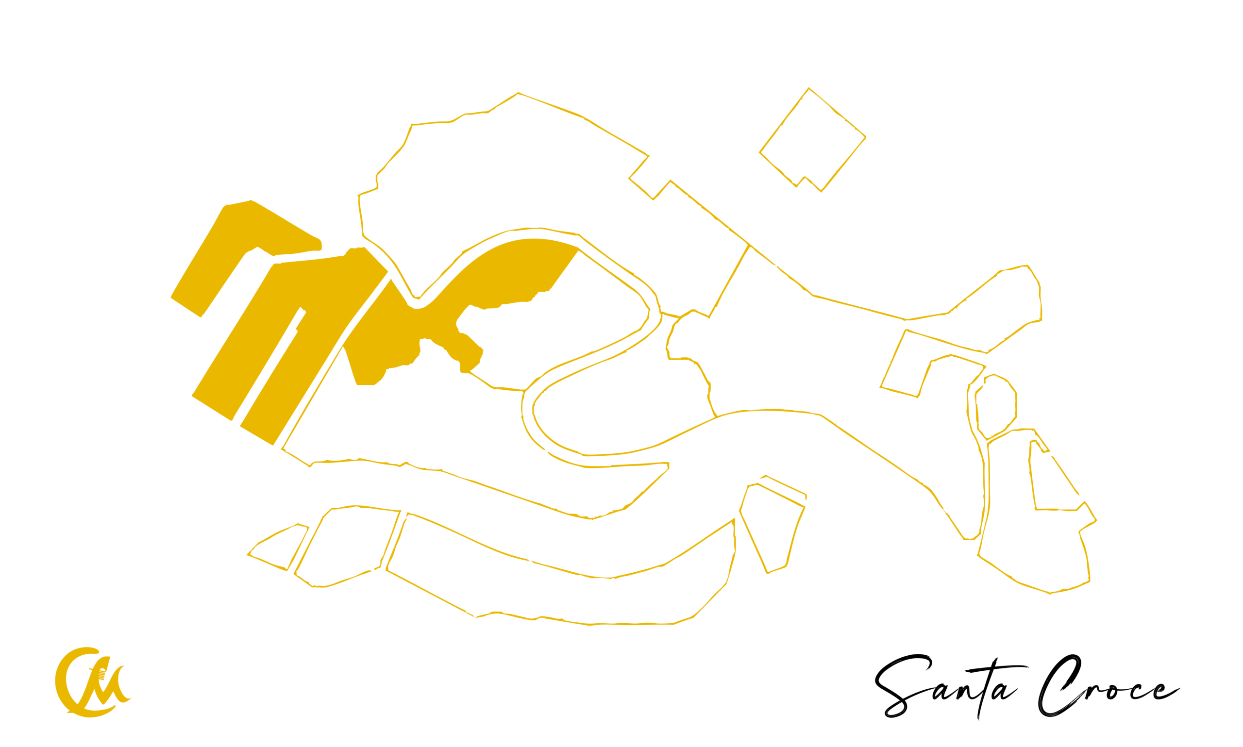
Sestiere of Santa Croce
The Sestiere of Santa Croce is the smallest of Venice's six Sestieri and serves as the city's main gateway for visitors arriving from the mainland. It is also the only Sestiere where motor vehicles are permitted, although only within the limited area of Piazzale Roma, Venice's road transport hub. The district takes its name from the ancient Church of Santa Croce, originally founded in the 7th century. Following the Napoleonic suppressions in the early 19th century, the church was demolished, and today only a single column survives, incorporated into the wall surrounding the Papadopoli Gardens. These gardens are now one of the few significant green spaces in the historic centre, a reminder of an area that was largely transformed by urban development following the construction of Santa Lucia Railway Station. In its earliest history, Santa Croce occupied what was then the outskirts of Venice. Before the construction of bridges connecting the city to the mainland, Venice could only be reached by boat, and this area consisted largely of marshes and salt flats known as Luprio, a name traditionally associated with wolves that may once have inhabited the area. Over time, the land was reclaimed and cultivated with vineyards and vegetable gardens. The district underwent its greatest transformation from the mid-19th century onwards with the construction of the railway bridge, followed in 1933 by the opening of the Ponte della Libertà, the road bridge linking Venice to the mainland. During the 20th century, further developments—including the Maritime Station, Piazzale Roma, the Rio Novo Canal, and the artificial island of Tronchetto—turned the northern part of Santa Croce into Venice's principal transport hub for cars, buses, and cruise passengers. Today, Santa Croce is characterised by its quiet narrow calli, peaceful canals, and intimate squares. It is the only Sestiere where ancient Venice, modern infrastructure, and contemporary urban life coexist side by side. Although it is home to fewer famous monuments than other parts of the city, Santa Croce offers visitors an authentic atmosphere and a fascinating blend of history, architecture, and everyday Venetian life.
What to See: - People Mover (automated transport system connecting Tronchetto Island to Piazzale Roma) - Cittadella della Giustizia (Judicial Citadel) - Former Church of Sant'Andrea della Zirada - Constitution Bridge - Church of San Simeone Piccolo - Scalzi Bridge - Church of San Simeone Profeta (San Simeone Grande) - Fontego dei Turchi (Natural History Museum) - Church of San Zan Degolà (Church of San Giovanni Battista Decollato) - Church of San Giacomo dell'Orio - Fontego del Megio - Belloni Battagia Palace - Church of San Stae - Ca' Pesaro Palace (Museum of Oriental Art and International Gallery of Modern Art) - Palazzo Mocenigo Museum (Museum of Textiles, Costume and Perfume) - Ca' Corner della Regina (home of the Prada Foundation) - Church of San Nicola da Tolentino - Calle Ca' Zusto (Venice's narrowest street, only 65 cm / 26 in wide) - Church of San Cassiano - Church of Santa Maria Mater Domini
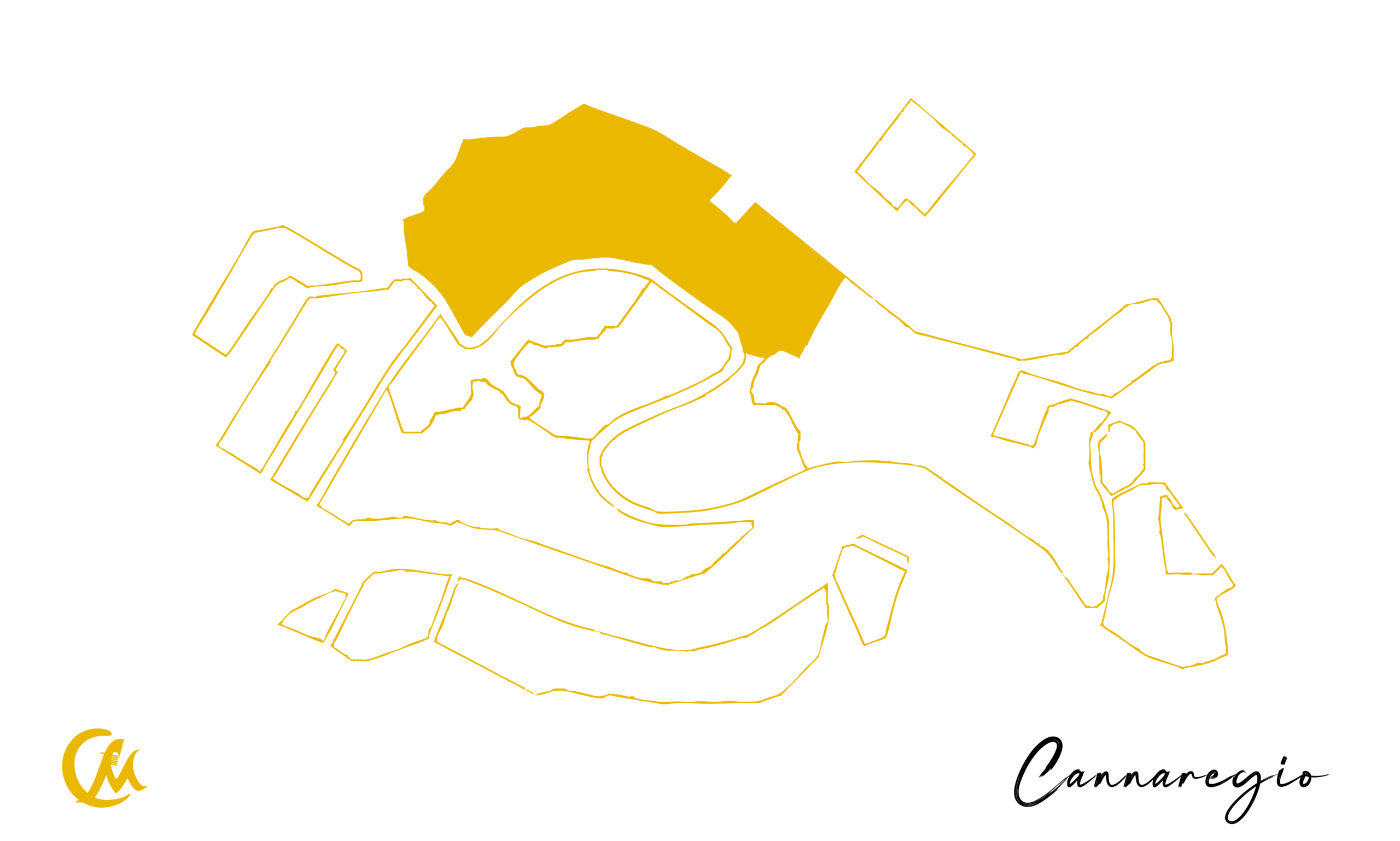
Sestiere of Cannaregio
It is the most populated Sestiere of Venice and, after Castello, the second largest in size.
The origin of the name Cannaregio is uncertain and has been explained through several theories. The most widely accepted suggests it derives from the extensive “canneti” (reed beds)—marshy or clay-rich land covered with wild grasses that once dominated the area when it was still uninhabited.
Another theory links the name to the main waterway, the Canal Cannaregio, originally called the Canal Regio. A further hypothesis traces it back to the Latin word “canaliculus” (small canal), referring to a minor watercourse that crosses the Sestiere and flows into the lagoon.
From this area, Venice’s first land connection to the mainland was established with the construction of the Santa Lucia Railway Station, marking a major transformation in the city’s modern history.
Cannaregio was also home to several major historical figures, including Marco Polo, Tintoretto, and Tiziano.
What to See: - Church of Santa Maria di Nazaret (Church of the Scalzi) - Sanctuary of Santa Lucia - Palazzo Labia - Palazzo Savorgnan - Guglie Bridge - Three Arches Bridge - Jewish Quarter - Ghetto Vecchio - Ghetto Nuovo - Jewish Museum - Church of Madonna dell’Orto - Tintoretto’s House - Scuola Grande di Santa Maria della Misericordia - Venice Casino - Chiodo Bridge - Ca' d'Oro - Church of Santa Maria dei Miracoli - Calle Varisco - Church of the Jesuits
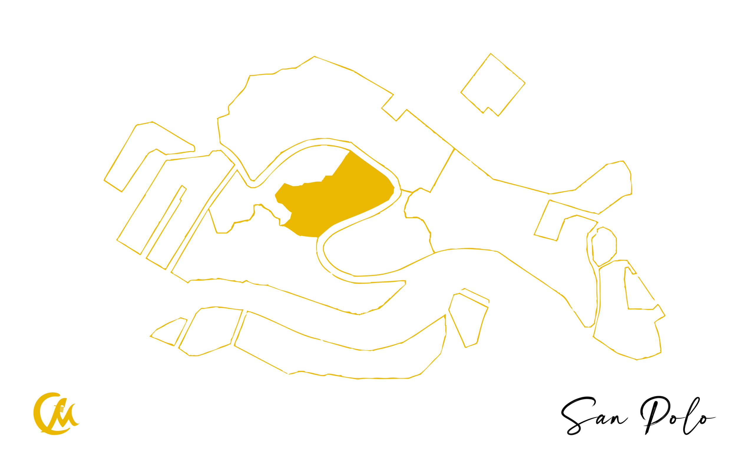
Sestiere of San Polo
It is the smallest Sestiere of Venice and, together with Santa Croce, originally formed a single large area known as “Luprio”, where the Republic of Venice once operated its historic salt marshes.
The name San Polo comes from its most important church, San Paolo Apostolo (commonly called by Venetians the Church of San Polo), located in the central Campo San Polo, the largest square in Venice after St. Mark’s Square.
Although it is the smallest Sestiere in terms of surface area, San Polo is one of the most vibrant areas of the city, rich in artisan workshops and traditional Venetian taverns known as “bacari”.
Its most historically significant area is Rialto, once part of the same urban nucleus as the current Sestiere of San Marco, and still considered the commercial heart of Venice. Today, San Polo is also one of the most popular districts for shopping and nightlife, especially among younger visitors.
What to See: - Rialto Bridge - Rialto Market - Church of San Giacomo di Rialto - Campo San Polo - Church of San Polo - Carlo Goldoni’s House (Museum of Theatre) - Church of San Tomà - Basilica of Santa Maria Gloriosa dei Frari - Scuola Grande di San Rocco (Museum dedicated to Tintoretto) - Church of San Rocco - Church of San Giovanni Evangelista
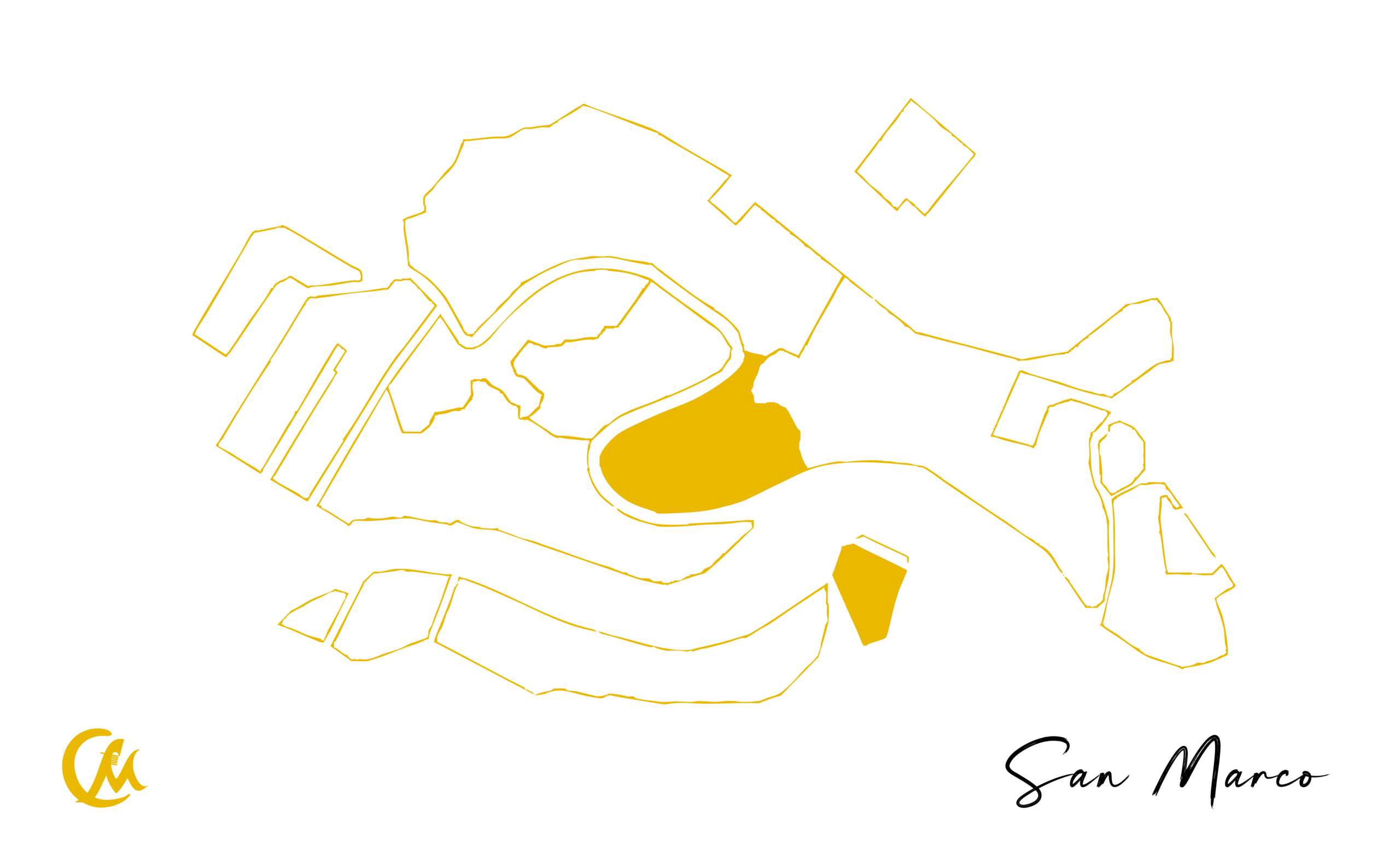
Sestiere of San Marco
It is the oldest, most famous, most important, and most magnificent Sestiere of Venice, the true beating heart of the city since its very origins.
The Sestiere of San Marco is located in the very centre of Venice. In antiquity it was known as Rivoalto (from which the name Rialto derives) and it represents the original core from which the city later developed and expanded. In Roman times, the area was referred to as “Civitas Rivoalti”, in reference to the first lagoon islands where the earliest settlements were established.
At the heart of the Sestiere lies St. Mark’s Square, which for nearly a millennium served as the political (Doge’s Palace) and judicial (Procuratie) centre of the Republic of Venice.
The square developed over the area once occupied by ancient “brolo” gardens, cultivated by the nuns of the convent of San Zaccaria, and around two early churches: the Church of San Teodoro (later demolished to make way for St. Mark’s Basilica) and the first Church of San Geminiano, originally located halfway along the present square facing the Basilica.
With the expansion of the square, the Church of San Geminiano was rebuilt and later permanently demolished in 1807 by order of Napoleon, in order to construct the present Napoleonic Wing, commissioned as a ballroom and now housing the Correr Museum.
The name of the square and the Sestiere was established after the year 828, when tradition recounts that two Venetian sailors, Buono da Malamocco and Rustico da Torcello, stole the relics of St. Mark the Evangelist from Alexandria in Egypt and brought them to Venice. To house the relics, the Church of San Teodoro was demolished and the present St. Mark’s Basilica was built, where the remains are still preserved today.
Venice’s first patron saint was not St. Mark, but St. Theodore of Amasea (San Todaro in Venetian dialect). St. Mark became the city’s patron only in 862, symbolised by the famous Winged Lion, known as the Lion of St. Mark. Both saints are still considered protectors of the city, as symbolised by their statues placed on the two columns at the entrance of St. Mark’s Square overlooking the St. Mark’s Basin.
These columns were brought from the East as war booty at the end of the 12th century (a third column was lost at sea during transport). Their erection was successfully engineered by Nicolò Barattieri, who devised an innovative lifting method. As a reward, he was granted permission to organise gambling activities between the columns, a rare privilege in the Republic of Venice where gambling was otherwise prohibited.
In medieval and Renaissance times, the space between the columns was also used for executions. Due to long-standing superstition, many Venetians still avoid walking directly between them today.
The Sestiere of San Marco brings together all of this—and much more.
What to See: - St. Mark’s Square - St. Mark’s Basilica - St. Mark’s Campanile - Clock Tower (Torre dei Mori) - Piazzetta dei Leoncini - Piazzetta San Marco - Napoleonic Wing (Correr Museum) - Procuratie Vecchie and Nuove - Bacino Orseolo - Doge’s Palace - Porta della Carta - Biblioteca Marciana - Zecca (Mint) Palace - Royal Gardens - Kaffeehaus - Church of San Giorgio Maggiore - Bridge of Sighs - Riva degli Schiavoni - La Fenice Theatre - Church of Santa Maria del Giglio - Palazzo Barbarigo Minotto - Music Museum - Ca’ Corner della Ca’ Granda - Campo Santo Stefano - Palazzo Franchetti - Church of San Vidal - Casanova Museum (virtual museum) - Palazzo Grassi (Contemporary Art Museum) - Scala Contarini del Bovolo - Church of San Salvador - Campo San Bartolomeo - Church of San Bartolomeo - Fondaco dei Tedeschi (Shopping)
Sestiere of Dorsoduro
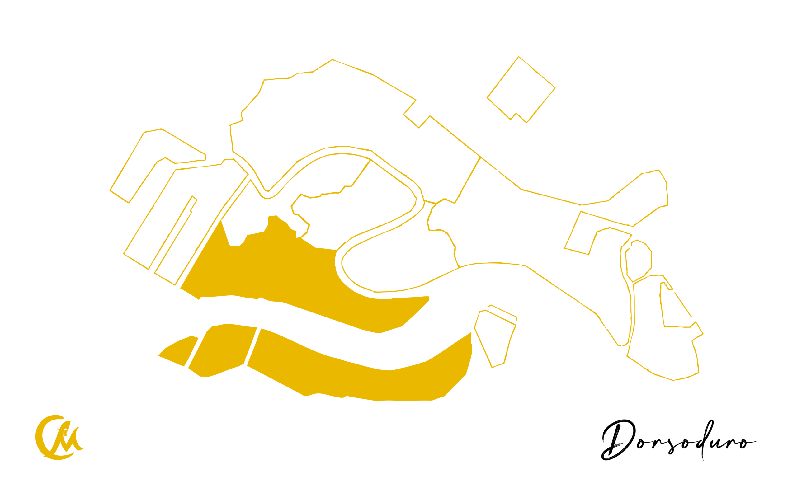
It is the southernmost Sestiere of Venice. Its name is believed to derive from the fact that, in ancient times, this area was less marshy and had firmer ground compared to the rest of the lagoon, literally meaning a “harder back” (dorsum).
Among the earliest parts of the city to be settled, its western area included the island of Mendigola. Today, this historic zone corresponds to where the Church of San Nicolò dei Mendicoli was built in the 7th century, one of the oldest churches in Venice. The name of the church is thought to derive either from Mendigola, the ancient name of the island, or from mendici, referring to the modest living conditions of the area’s inhabitants.
This district was historically home to the “Nicolotti”, one of the two major factions of Venetian workers, particularly associated with the Arsenal. They were in constant rivalry with the “Castellani”, who came mainly from the Sestiere of Castello and parts of San Marco. Their rivalry often led to organised hand-to-hand fights on the so-called “Ponte dei Pugni” (Bridges of Fists)—the most famous of which is located in Campo San Barnaba. These bridges had no protective railings, and the objective was to push opponents off until one team reached the opposite side. The Venetian government tolerated—and even encouraged—this rivalry as a form of training for physical strength and combat readiness.
The territory also includes the Canal della Giudecca and the island of Giudecca, which administratively belongs to the Sestiere but maintains its own civic numbering system.
Today, Dorsoduro is also a major university district, hosting some of Venice’s most important academic institutions. It is second only to San Marco in terms of concentration of churches, palaces, and museums, making it one of the richest cultural areas of the city.
What to See: - Church of San Pantalon - Campo Santa Margherita - Ca’ Rezzonico Gardens - Ponte dei Pugni - Church of the Carmini - Church of San Nicolò dei Mendicoli - Church of the Angel Raphael - Church of San Sebastiano - Squero di San Trovaso - Gallerie dell’Accademia - Accademia Bridge - Peggy Guggenheim Collection - Palazzo Dario - Former Church of San Gregorio - Basilica of Santa Maria della Salute - Punta della Dogana - Magazzini del Sale - Giudecca Island
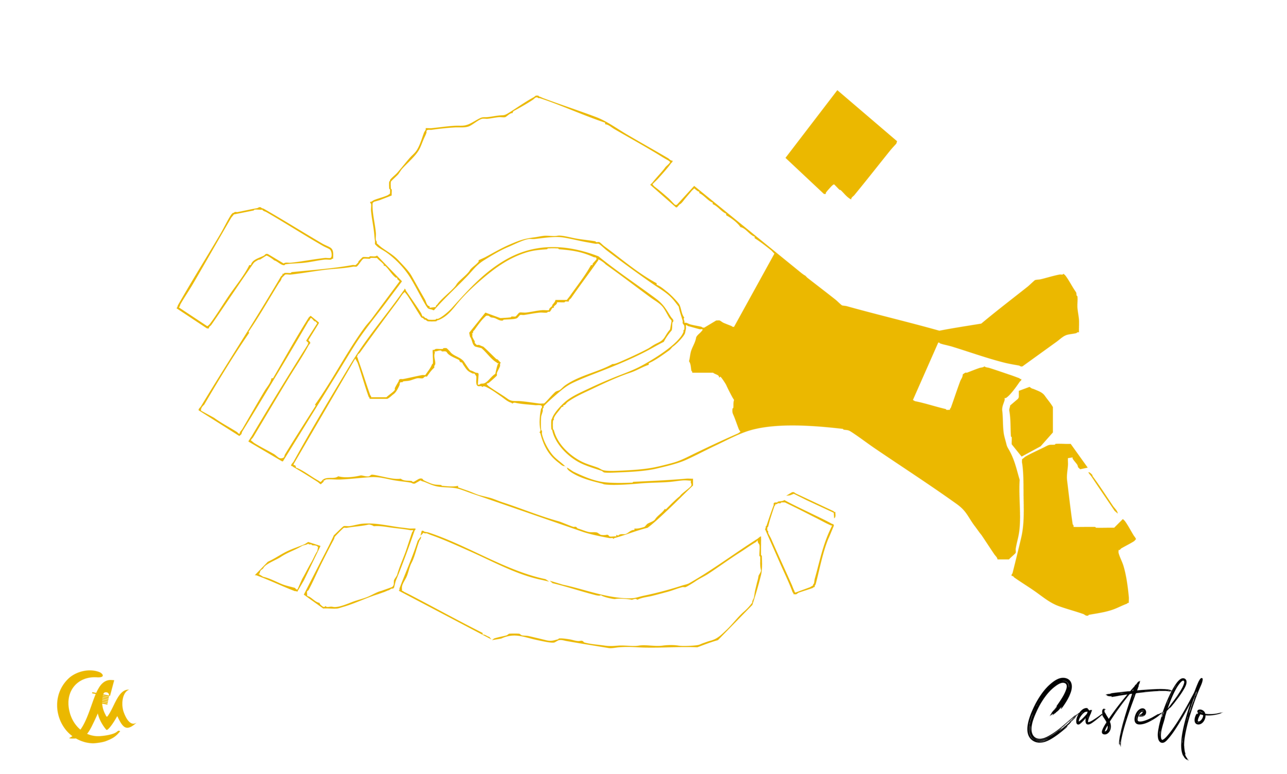
Sestiere of Castello
È il Sestiere più esteso e Orientale di Venezia e il secondo più popolato e deve il suo nome al Castello che venne costruito qui sull’isola di Olivolo (oggi isola si San Pietro) nell’alto medioevo per proteggersi dagli attacchi via terra e per monitorare la situazione via mare. Il forte doveva inizialmente sorgere dove oggi si trova l’Arsenale e far parte probabilmente di un sistema difensivo più articolato comprendente una seconda fortificazione vicino Palazzo Ducale e una cinta muraria per difendere la città dalle invasioni degli Ungari tra il IX e X secolo. Alle origini era diviso nelle due isole Gemine (il nome deriva per la presenza di due isole vicine) e l’isola di Olivolo (nome deriva probabilmente dalla forma a oliva dell’isola), unite in seguito a costituire il Sestiere. Fu sede della prima Diocesi autenticamente Veneziana e della prima Cattedrale dedicata a San Pietro. È l’unico Sestiere che non si affaccia sul Canal Grande e rappresenta una delle zone meno visitate dai turisti mantenendo nel tempo la sua autenticità.
What to See: - Basilica of San Pietro in Castello - San Pietro Canal - Giardino delle Vergini - Garibaldi Gardens - Church of San Giuseppe di Castello - Napoleonic Gardens (also known as Biennale Gardens) - Riva dei Sette Martiri - Naval History Museum - Venetian Arsenal - Church of San Francesco della Vigna - Dalmatian School of Saints George and Tryphon - Hellenic Institute - Riva degli Schiavoni - Church of San Giovanni Battista in Bragora - Church of San Giorgio dei Greci - Church of San Zaccaria - Libreria Acqua Alta - Basilica of Saints John and Paul - Church of Santa Maria Formosa - Palazzo Querini Stampalia - Arch of Paradise